Shaula sits at right ascension 17.56014 hours and declination -37.10382 degrees, shining at apparent magnitude 1.62 in the tail of Scorpius. That is the entire entry in the HYG v41 catalogue, and it is also the entire brief a chartmaker works from. Everything else on the printed map — the size of the dot, the label placement, the line to Lesath, the fact that the star appears at all on your sheet — is a decision made from those three numbers. This piece walks the decision tree in the order the desk actually walks it, one fork at a time.
Question 1: Are You South of Roughly 53° North Latitude?
This is the first fork because it decides whether Shaula belongs on the map at all. A star at declination -37.10382° never climbs high in northern skies, and past a certain latitude it never rises. The old chartmaker's rule of thumb: a star is circumpolar-invisible when its declination is more negative than your latitude minus 90°. Run the arithmetic. From 53° N, the southernmost point of the sky that ever clears the horizon sits at declination -37° exactly. Shaula is at -37.10382°. It theoretically grazes the horizon and, in practice, is drowned in atmosphere and terrestrial haze. From 55° N — Edinburgh, Moscow, the middle of Denmark — it is gone.
That number, -37.10382°, is the reason the question is not "are you in the northern or southern hemisphere". It is a specific latitude line pulled directly from the catalogue coordinate.
If Yes (You Are South of ~53° N)
Shaula goes on the map. The next choice is where on the map. Right ascension 17.56014 hours places the star in the northern-summer, southern-winter sky — the same coordinate band as the Milky Way core, Sagittarius, and the rest of Scorpius. On a full-hemisphere chart drawn for a mid-latitude observer (say 30° N or 30° S), Shaula will land toward the lower edge if the map is oriented with north up. It is a low southern star for anyone in the temperate north, and a comfortably high one for anyone in Sydney, Cape Town, or Buenos Aires.
The chartmaker's next micro-decision is horizon clipping. On a rectangular sky chart, we draw the star even if it never rises for the assumed observer — as a light-grey dot below a shaded band — because the map is a picture of the celestial sphere, not a picture of what you personally will see tonight. On a planispheric chart tuned to a specific latitude, Shaula gets clipped or greyed out below the horizon ring. Same star, different render, same coordinate.
If No (You Are North of ~53° N)
Shaula is not on your local map, and drawing it would be a lie about the sky above your head. This is not a small point. A chart is a promise: everything printed here is theoretically visible from where the map is drawn for. Break that promise once, and the reader loses the ability to use the chart as a finder. So we do one of three things. We draw the map for a lower latitude and label it that way ("Sky chart, 40° N, mid-July, 22:00 local"). We draw a full-hemisphere reference chart, which shows every star including the ones you cannot see, and label the horizon ring. Or we simply do not include Shaula in the constellation figure — Scorpius, from far northern latitudes, is a partial constellation, and honest charts show it as one.
The catalogue does not care whether you can see the star. The chart does. That is the entire job.
Question 2: Do You Read the Magnitude Dot as a Size or as a Brightness?
Every star chart draws stars as dots of varying diameter. The eye reads the diameter as "brightness". This is a translation, and translations lose things. Magnitude 1.62 is not a size. It is a logarithmic number on a scale where lower is brighter and each five-step drop equals a hundredfold decrease in flux. Shaula, at 1.62, sits inside the top thirty naked-eye stars in the entire sky. On the chart, that reality has to become a black dot roughly two to three millimetres across, next to a magnitude-4 dot half a millimetre wide.
The question matters because the chartmaker has to decide the transfer function. Linear diameter to magnitude flattens the bright end. Logarithmic transfer over-emphasises it. Every chart is a compromise curve, and where Shaula sits on that curve is a specific editorial choice.
If You Read It as Size
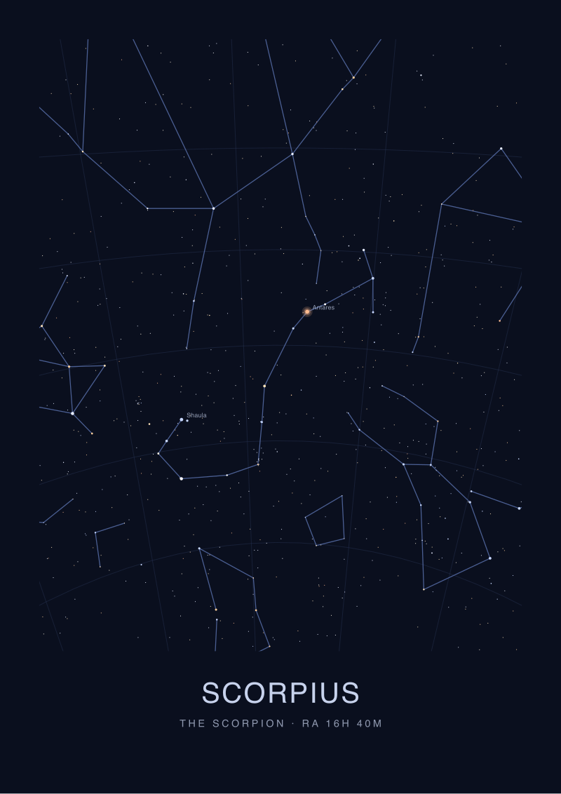
You are reading the map the way most beginners do, and that is not wrong — the size hierarchy carries the constellation figure. Shaula's dot should be visibly larger than its neighbour Lesath, even though the two stars sit close on the sky and are often mistaken for a pair. Lesath is fainter. The dot ratio on a well-drawn chart is roughly the ratio you would perceive with the naked eye on a clear night: Shaula noticeably dominant, Lesath a close, humbler companion. If both dots print at the same diameter, the chart is lying by omission.
Reading dots as size also means the star's position on the constellation stick figure carries weight. Shaula is the sting. It is drawn at the terminal joint of a line that curves from Antares down through the tail, and the size of the dot signals "this is the anchor point of the figure". Drop the dot to magnitude-3 diameter and the sting reads as an afterthought.
If You Read It as Brightness
You are reading the map the way an experienced observer does — as a proxy for what the naked eye will register at the eyepiece or under the sky. Magnitude 1.62 means Shaula will be one of the very first stars to appear at nautical twilight, when the sky is still cobalt-blue and only the brightest points have punched through. On a chart that shades progressively for twilight visibility, Shaula belongs in the earliest tier. This is why the dot is not just larger — it is often drawn with a faint halo or corona on high-end charts, signalling "this star reads as a light source, not just a point".
The magnitude scale runs backwards on purpose and against every intuition. Hipparchus in the second century BCE ranked the visible stars from "first magnitude" (the brightest twenty or so) down to "sixth" (the faintest naked-eye), and the modern system inherited the direction. The chartmaker cannot fix it. What we can do is make the visual hierarchy carry the meaning the numbers refuse to carry by themselves.
 Scorpius
The print from this article · from €29.95
View the print →
Scorpius
The print from this article · from €29.95
View the print →
Question 3: Are You Reading the Position as Sky Coordinates or as a Picture?
Right ascension 17.56014 hours and declination -37.10382° is a coordinate pair. It is also, once you commit ink to paper, a location on a rectangle. Those two things are not the same, and every projection choice made between the catalogue and the chart affects where Shaula appears relative to every other star around it. The question is whether the reader is expected to treat the map as a coordinate lookup (a grid to be read like graph paper) or as a picture (a compressed rendering of the actual visual scene).
If Coordinates
The chart uses an equatorial grid — RA in hours across the horizontal, declination in degrees on the vertical — and Shaula is placed at the intersection. This is what star atlases like the Uranometria and Sky Atlas 2000.0 do. It preserves position at the cost of shape: near the poles, constellations distort, and at high declinations north or south the equatorial rectangle stretches stars into unnatural configurations. At Shaula's declination of -37°, distortion is mild but present. The map is honest about the coordinate, and the reader is expected to know that the printed shape is not exactly what the eye will see.
On a coordinate chart, RA 17.56014 hours parses cleanly. Convert to hours-minutes-seconds: 17h 33m 36.5s. Convert the declination: -37° 06' 13.7". Those are the numbers a chart legend will print next to the star, and they are the numbers a telescope's setting circles will accept.
If a Picture
The chart uses a projection tuned to preserve visual shape — often stereographic or gnomonic for a chart of a single constellation, or an azimuthal equidistant for a whole-sky planisphere. Shaula's placement is now a compromise between the coordinate and the appearance. The stinger's characteristic curve, that hook at the tail of Scorpius, has to look right. If preserving the coordinate stretches the curve, a picture-chart bends the projection to keep the visual truth.
This is why constellation art works better on gnomonic projection over a limited area and why full-sky wall charts always have some region where the shapes look wrong. Scorpius, drawn in a picture-first projection, will render Shaula and Lesath as the tight pair the naked eye actually sees. Drawn on a coordinate-first Mercator, the tail will unroll a little too straight.
If You Answered Everything
The eight combinations resolve to eight distinct chart types. Read this as the recipe card the desk works from.
| Q1 (South of 53°N?) | Q2 (Dot as size or brightness?) | Q3 (Coordinates or picture?) | Recommendation |
|---|---|---|---|
| Yes | Size | Coordinates | Standard mid-latitude atlas chart; Shaula drawn as a mag-1 dot at RA 17h 33m, dec -37°. |
| Yes | Size | Picture | Constellation card for Scorpius; the sting anchors the figure, Lesath sits close alongside. |
| Yes | Brightness | Coordinates | Observer's finder chart; Shaula halo-marked as an early-twilight star for planning nautical dusk. |
| Yes | Brightness | Picture | Southern-sky art print; Shaula rendered as a luminous point weighted for atmospheric-visible feel. |
| No | Size | Coordinates | Full-hemisphere reference chart; Shaula printed but below the horizon shading for the reader's latitude. |
| No | Size | Picture | Scorpius illustrated as a partial constellation, or a chart drawn for a lower reference latitude. |
| No | Brightness | Coordinates | Planning chart for a southern travel trip; Shaula tiered as first-tier twilight star at the destination. |
| No | Brightness | Picture | Studio decorative print of a sky the reader cannot see from home — a picture, not a finder. |
The three questions and their eight combinations cover every legitimate reason Shaula appears on a printed page. Notice what is not in the table. Nothing here is about personality, temperament, or fortune. The sting of Scorpius, in every one of these charts, is a magnitude-1.62 star at RA 17h 33m 36.5s and declination -37° 06' 13.7", drawn according to who is reading and why. The zodiac's coordinate band brushes past this region, but Shaula sits below the ecliptic and outside it — a coordinate fact, not a symbolic one.
Every mark on a Sky Atlas print of Scorpius is one of the answers on that table made permanent in ink. The dot size answers Q2. The projection answers Q3. Whether the sting appears at all answers Q1. That is what a star map records: not the sky in general, but a set of choices about how to draw one particular star for one particular reader. Shaula makes those choices easy — bright enough to demand a dot, southern enough to test your latitude, tight enough with Lesath to demand a projection with opinions.
 The Winter Sky
The print from this article · from €29.95
View the print →
The Winter Sky
The print from this article · from €29.95
View the print →
FAQ
Why is Shaula's magnitude given as 1.62 instead of a rounder number like 1.6?
Catalogue precision matters when charts are ranked against each other. HYG v41 lists Shaula at exactly 1.62, and the two-decimal value distinguishes it from close neighbours on the brightness scale. Rounding to 1.6 loses the fine sort order that determines dot-diameter tiers on a well-drawn map. The chartmaker keeps the extra digit even if the printed dot cannot render the difference — the ranking survives even when the mark cannot.
Is Shaula a single star or something more complicated?
The HYG v41 entry lists Shaula as a single catalogue point at RA 17.56014 hours and declination -37.10382°. Anything beyond that — multiplicity, spectral behaviour, physical companions — belongs to other astronomical sources and is not part of the chart brief. A star map treats the catalogue coordinate as one printed dot. Deeper structure is a topic for astrophysics, not cartography, and Sky Atlas charts draw the coordinate as given.
How do I convert RA 17.56014 hours into hours, minutes and seconds?
Take the whole number as hours: 17h. Multiply the decimal 0.56014 by 60 to get minutes: 33.6084 minutes, so 33m. Multiply the remaining decimal 0.6084 by 60 to get seconds: 36.5s. The full coordinate reads 17h 33m 36.5s. Right ascension is measured in time units because the celestial sphere rotates once every sidereal day, and dividing that rotation into 24 hours makes tracking motion across the sky arithmetically simple.
What is the difference between Shaula and Lesath on a chart?
Both stars appear close together at the tip of the scorpion's tail, but they are drawn differently because they are different brightnesses. Shaula at magnitude 1.62 gets the larger dot; Lesath is fainter and gets a proportionally smaller mark. On the naked-eye sky they read as a tight pair, and a good chart preserves that pairing while still signalling the brightness gap through dot diameter. Confusing the two on a print is the map's failure, not the reader's.
Can I see Shaula from the United Kingdom or northern Europe?
No, not meaningfully. At declination -37.10382°, Shaula theoretically clears the horizon only from latitudes south of roughly 53° N. That includes southern England on paper, but atmospheric extinction near the horizon flattens a magnitude-1.62 star to invisibility in practice. From Manchester northward, Scotland, or anywhere in Scandinavia, the star does not rise. Charts drawn for those latitudes should either omit Shaula or clearly grey it below the horizon ring.
Why is the magnitude scale reversed — lower numbers for brighter stars?
The convention comes from Hipparchus in the second century BCE, who ranked visible stars into six magnitude classes with the brightest labelled "first". The system was formalised mathematically in the nineteenth century — five magnitudes equal exactly a hundredfold difference in brightness — but the direction was never flipped, because the historical labels were already in every atlas. Astronomers accept the inversion and work around it. Chartmakers translate it into dot size, which the eye reads correctly regardless of the underlying number.
Does Shaula sit in the zodiac?
No. Shaula is close to the ecliptic band that defines the zodiac but sits below it at declination -37.10382°. The ecliptic runs through the northern part of Scorpius, near Antares and the claws, before the Sun's apparent path passes into Ophiuchus. The sting of the scorpion, where Shaula lives, is well south of any zodiacal coordinate. The zodiac is a coordinate strip about the ecliptic, not a symbolic zone, and Shaula's declination places it firmly outside that strip.
What kind of map is best if I want to actually find Shaula tonight?
A finder chart drawn for your specific latitude and date, showing the horizon line and the twilight tier. Shaula is a first-tier twilight star, meaning it appears very early in the evening as the sky darkens, and its low southern altitude makes horizon clearance the practical limiting factor. From 30° N or south of that, an unobstructed southern horizon between May and August after nautical dusk is the working window. A picture-projection chart shows the sting's shape; a coordinate chart shows exactly where to point.
From the collection
New charts and 10% off your first print.
One email now with your code. No noise after.